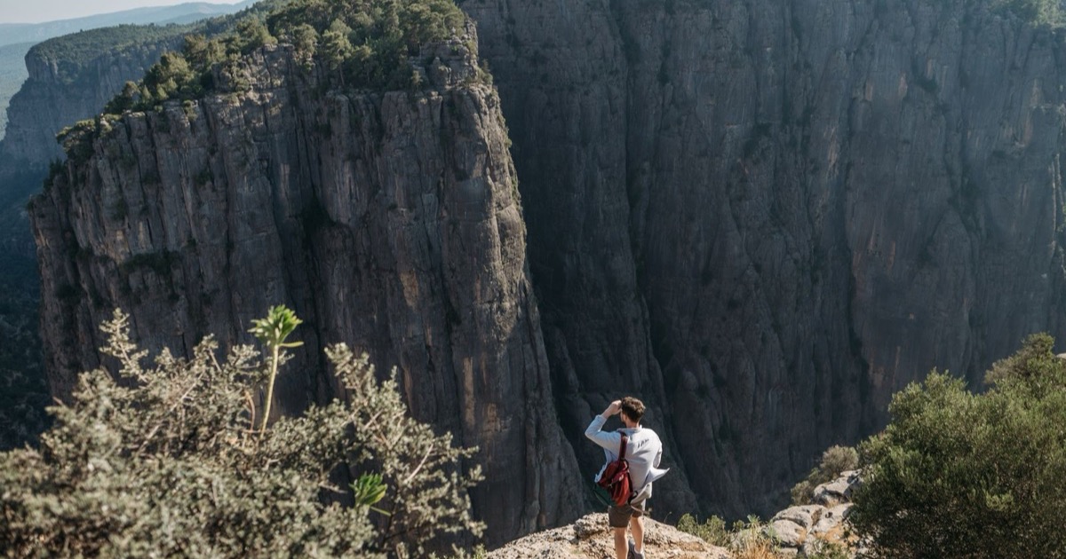

For hikers seeking a compact yet rewarding trek, the Dilek Peninsula Canyon hike guide offers a clear roadmap to one of Turkey’s most striking Aegean coast experiences.
For hikers seeking a compact yet rewarding trek, the Dilek Peninsula Canyon hike guide offers a clear roadmap to one of Turkey’s most striking Aegean coast experiences. The Upper Dilek Canyon Loop delivers a 9.2‑kilometre circuit that threads through limestone cliffs, hidden ravines, and seasonal streams, all within the protected bounds of Dilek Peninsula National Park. This part of the park is easily reachable from major towns such as Kuşadası, making it a practical day‑trip option for both locals and travelers. Follow the details below to plan a confident and enjoyable canyon trek.
What makes the Upper Dilek Canyon Loop a unique hiking experience?
The loop’s compact length masks a surprising variety of micro‑environments. Hikers begin on a shaded forest trail where pine and oak mingle with fragrant thyme, then quickly emerge onto a series of narrow limestone passages that open onto panoramic views of the Aegean Sea. The contrast between cool, moss‑damp rock faces and sun‑lit cliff edges creates a dynamic setting that keeps the route interesting from start to finish.
Another distinctive element is the presence of several small waterfalls that appear after periods of rain. These seasonal cascades feed clear pools that hikers can use for a quick splash before continuing. The trail also intersects with ancient footpaths that once linked coastal settlements, offering subtle hints of the region’s archaeological past without overwhelming the natural focus of the hike.
How long is the Dilek Peninsula canyon trail and what terrain does it cover?
The main circuit measures 9.2 kilometres, a distance that most fit walkers can complete in three to four hours, depending on pace and the number of stops taken for photography or rest. The route is divided into three primary sections: an initial forested approach, a mid‑section of rugged limestone climbing, and a final descent that returns to the parking area via a gentler slope. Each segment presents a different set of challenges, from uneven root‑covered paths to rocky scrambles that require careful footing.
Elevation change is modest but noticeable; the trail climbs roughly 250 metres from the valley floor to the highest lookout point, then drops back down along a series of switchbacks. The terrain is primarily composed of limestone, which creates sharp edges and occasional narrow ledges. In spring, wildflowers dot the lower slopes, while autumn brings a palette of golden oak leaves that soften the rocky backdrop.
Visitors often wonder how the loop compares to other hikes in the park. The table below highlights key differences between the Upper Dilek Canyon Loop and two alternative routes that are frequently mentioned in travel guides.
| Trail | Length (km) | Elevation Gain (m) | Typical Duration | Key Features |
|---|---|---|---|---|
| Upper Dilek Canyon Loop | 9.2 | ≈250 | 3–4 hrs | Limestone cliffs, seasonal waterfalls, historic footpaths |
| Southwest Coastal Trail | 12.5 | ≈180 | 4–5 hrs | Beach access, panoramic sea views, longer forest sections |
| Mountain Ridge Loop | 15.0 | ≈420 | 5–6 hrs | Higher altitude, extensive ridge walking, wildlife spotting |
What is the difficulty level of the Dilek Canyon hike and who is it suitable for?
Overall, the Upper Dilek Canyon Loop is classified as moderate. The combination of uneven ground, occasional rock scrambling, and a steady ascent means that hikers should possess a reasonable level of fitness and be comfortable with basic trail navigation. Proper footwear with good ankle support is strongly recommended, as the limestone sections can become slippery after rain.
The hike is well suited to experienced day‑hikers who enjoy a mix of forest and rocky terrain, as well as families with older children who are comfortable with short climbs. Beginners may find the steepest portions challenging, but the trail is clearly marked, and there are several rest spots where a pause is possible without losing momentum.
For those who prefer additional support, guided tours are available from local operators near the park entrance. These tours typically include a brief safety briefing, a trail map download, and a knowledgeable guide who can point out geological formations and historical landmarks along the way. Whether you choose to go solo or join a group, the loop offers a rewarding balance of physical effort and natural scenery.
When is the best season to hike the canyon on the Dilek Peninsula?
The canyon is most comfortable during the shoulder months of late spring (mid‑April to early June) and early autumn (mid‑September to early November). During this window daytime temperatures usually stay between 18 °C and 24 °C, and humidity is moderate, which reduces the risk of heat‑related fatigue on the 9.2 km loop. The limestone walls retain a gentle warmth after sunrise, making the early‑morning sections pleasant without the intense glare that can appear in midsummer.
Winter brings occasional rain and the possibility of slick rock surfaces, especially after the first snowfall in December. While the park remains open, the trail can become more demanding, and some of the lower‑lying beach access points may be closed due to high tides combined with storm surge. Summer (July‑August) offers the longest daylight hours, but temperatures often exceed 30 °C and the canyon can trap heat, increasing dehydration risk. If you choose to hike in this period, start before sunrise and carry ample water.
| Season | Average Day Temp | Trail Condition | Pros | Cons |
|---|---|---|---|---|
| Late Spring (Apr‑Jun) | 18‑24 °C | Dry, firm ground | Comfortable climate, abundant wildflowers | Occasional wind gusts on exposed ridges |
| Summer (Jul‑Aug) | 28‑34 °C | Dry, occasional dust | Long daylight, clear skies | Higher dehydration risk, hotter rock surfaces |
| Early Autumn (Sep‑Nov) | 19‑25 °C | Dry to slightly damp | Stable weather, fewer crowds | Shorter daylight after mid‑October |
| Winter (Dec‑Feb) | 9‑15 °C | Potentially wet, slippery sections | Cooler temperatures, quiet trails | Rain, possible trail closures |
What equipment and clothing should I bring for a safe canyon trek?
The canyon’s limestone terrain demands footwear with solid ankle support and a reliable grip. Trail runners with aggressive tread can work, but a lightweight hiking boot that protects against occasional loose stone is preferable. Layering is essential: a breathable base layer, an insulating mid‑layer for early‑morning chill, and a waterproof, wind‑resistant outer shell for unexpected showers.
Because the route follows a loop that includes shaded forest sections and open sun‑exposed ledges, a wide‑brimmed hat and UV‑blocking sunglasses help manage sun exposure. A compact daypack (20‑25 L) should accommodate hydration, navigation tools, and a basic first‑aid kit. Keep a small emergency blanket and a whistle in case you need to signal for assistance.
- Sturdy, waterproof hiking boots with ankle support
- Moisture‑wicking base layer and breathable mid‑layer
- Water‑resistant jacket with ventilation zippers
- Hydration system (minimum 2 L capacity) or multiple water bottles
- Headlamp with spare batteries (daylight can fade quickly in the canyon)
- Compact first‑aid kit (including blister treatment)
- Sun protection: hat, sunglasses, SPF 30+ sunscreen
Where can I find a reliable trail map or GPS route for the Dilek Canyon loop?
The official Dilek Peninsula‑Büyük Menderes Delta National Park website provides a downloadable PDF map that marks the Upper Dilek Canyon Loop, nearby water sources, and emergency exit points. The PDF is updated annually and includes contour lines that help gauge elevation changes along the circuit.
For GPS navigation, the park’s visitor centre offers a free QR code that links to a GPX file compatible with most handheld devices and smartphone apps such as OsmAnd or Gaia GPS. Local outdoor shops in the nearby towns of Kuşadası and Didim also sell printed topographic maps produced by the Turkish General Directorate of Mapping, which show detailed trail intersections and forest service roads.
Many hikers share their recorded tracks on community platforms like Wikiloc, where you can compare multiple versions of the loop to identify shortcuts or alternate viewpoints. When using crowd‑sourced data, verify the track against the official map to avoid unofficial detours that may cross private property or fragile habitats.
Are there any guided tour options for exploring the Dilek Peninsula canyon?
Several local operators based in Kuşadası and the nearby town of Didim run guided tours of the Dilek Peninsula canyon. These companies typically offer half‑day and full‑day packages that include transportation from the city center, a licensed natural‑history guide, and a brief safety briefing before the hike begins. Group sizes are usually limited to 8‑12 participants, which helps keep the pace comfortable and allows the guide to point out geological features such as the towering limestone cliffs Dilek and the narrow passages of the hidden ravines trail.
Most tours align the itinerary with the 9.2 kilometre circuit that forms the Upper Dilek Canyon Loop. Guides assign a hiking difficulty rating of moderate, noting that the route involves occasional steep sections and rocky footing but remains manageable for hikers with a reasonable level of fitness. For visitors who prefer a more flexible schedule, several operators provide private bookings that can be tailored to start earlier in the morning or extend the walk to include adjacent viewpoints.
Pricing generally covers the guide’s expertise, vehicle fuel, and a complimentary trail map download that highlights water sources, rest spots, and emergency contact points. Some packages also include a short cultural stop at nearby ancient ruins, offering a glimpse of the peninsula’s archaeological heritage before or after the canyon trek.
What wildlife and plant species might I encounter while hiking the canyon?
The canyon’s microclimate supports a blend of Mediterranean and Aegean ecosystems. As you follow the winding path, you may hear the rustle of small mammals in the underbrush and spot colorful insects perched on sun‑warmed rocks. Birdwatchers often report sightings of raptors circling the cliffs, while the forested sections host a variety of songbirds that add a lively soundtrack to the trek.
Vegetation ranges from hardy shrubs that cling to the limestone outcrops to fragrant herbaceous plants that bloom in spring. The diversity is especially noticeable after the first rains of the season, when the hidden ravines become carpeted with seasonal wildflowers. Below is a short list of common species you are likely to encounter:
- Wild thyme (Thymus serpyllum) – low‑lying aromatic herb that releases a subtle scent when brushed.
- Turkish pine (Pinus brutia) – dominant tree in the higher sections, providing shade along the trail.
- Rockrose (Cistus creticus) – shrub with pink‑white flowers, often found on sun‑exposed slopes.
- Fallow deer (Dama dama) – occasional sightings at dusk near the forest edge.
- Wild boar (Sus scrofa) – active during early morning or late afternoon; keep a respectful distance.
- European bee‑eater (Merops apiaster) – bright‑colored bird that may be seen hunting insects near the cliffs.
- Alpine iris (Iris germanica) – striking violet blooms that appear in shaded crevices after rain.
How do I access the trailhead and where is parking available near the canyon?
The Upper Dilek Canyon Loop begins at a marked trailhead located on the western side of the national park, just off the Dilek‑Büyük Menderes highway. From Kuşadası, follow the signs for “Dilek Peninsula National Park” and continue for approximately 12 kilometres; a small parking area appears just before the entrance gate. The road is paved and well‑maintained, though it can become narrow in the final stretch, so drivers should proceed with caution.
Parking near Upper Dilek Canyon is free for day‑use visitors, and the lot can accommodate up to 30 vehicles, including a few spaces designated for motorcycles and bicycles. During peak summer months the lot may fill quickly, so arriving early—ideally before 09:00—is advisable. For those who miss the primary lot, a secondary gravel parking area exists about 500 metres downhill, accessible via a short footpath that leads directly onto the hidden ravines trail.
Entrance to the park requires a modest fee, payable at the gate. Visitors should bring a printed or digital copy of the trail map download to confirm the route and locate nearby facilities such as restrooms and water fountains. Signage along the approach road points out the parking zones, and a park ranger is typically on duty to answer questions about trail conditions and the best time to visit Dilek Canyon.
What safety precautions should I take when navigating the limestone cliffs and ravines?
The Upper Dilek Canyon Loop traverses steep limestone walls that can become slick after rain, so sturdy, ankle‑supporting hiking boots with good tread are essential. Carry a lightweight climbing helmet if you plan to explore any vertical sections, and always keep a hand on the installed railings where they exist; the natural rock is prone to sudden break‑offs.
Before setting out, check the local weather forecast for wind or sudden thunderstorms, as high winds can increase the risk of falling debris. Share your intended route and expected return time with a friend or the park reception, and bring a fully charged mobile phone, a portable power bank, and a basic first‑aid kit. Staying on the marked trail reduces the chance of getting lost in the maze of side ravines that branch off the main circuit.
What nearby attractions can I combine with a day of hiking the Dilek Canyon?
Just a short drive from the canyon trailhead lies the crystal‑clear cove of Kumkoy, a popular spot for a quick swim or a relaxed lunch on the sand. The same shoreline offers easy access to the ancient ruins of Mycale, where remnants of classical temples overlook the Aegean and provide a glimpse into the region’s layered history.
For wildlife enthusiasts, the Büyük Menderes Delta lies to the north of the park and is recognized as an important bird‑migration corridor; guided boat tours depart from nearby towns and allow you to observe waterfowl in their natural habitat. If you prefer a cultural finish, the historic market streets of Kuşadası are within a 30‑minute drive, offering cafés, local crafts, and a chance to sample regional cuisine after your hike.
Sources & Further Reading
Frequently Asked Questions
Is the Upper Dilek Canyon Loop suitable for beginners?
The 9.2‑kilometre circuit includes sections of moderate ascent and occasional narrow ledges, which can be challenging for those without basic hiking experience. Beginners who are comfortable with steady uphill walking and who use proper footwear can complete the loop, but they should avoid attempting any off‑trail climbing. Starting early in the day helps keep the temperature manageable and reduces exposure to crowds.
How much time should I allocate to complete the entire canyon circuit?
Most hikers finish the loop in three to four hours, depending on pace and how often they stop to enjoy the views. Adding extra time for photo breaks, a short rest at a shaded spring, or a quick dip in a nearby pool can extend the outing to five hours. Planning for a half‑day ensures you have enough margin for unexpected delays.
Can I hike the canyon in the summer without extreme heat concerns?
Summer temperatures on the peninsula often exceed 30 °C, and the canyon’s exposed sections can feel hotter due to reflected sunlight on the limestone. To stay comfortable, start the hike before sunrise or wait until the late afternoon when the sun is lower. Carry plenty of water, wear a wide‑brimmed hat, and apply sunscreen regularly.
Are there any water sources or refill stations along the trail?
Natural springs appear intermittently along the route, but their flow can be seasonal. The park provides a few marked water points near the main trailheads, where potable water is available from tap stations. It is safest to carry at least two litres of water per person and refill whenever you encounter a reliable source.
Do I need a permit or entrance fee to hike within Dilek Peninsula National Park?
All visitors must purchase a day‑pass at the park entrance; the fee contributes to trail maintenance and conservation efforts. No additional permit is required for the Upper Dilek Canyon Loop, but the pass must be displayed on a visible part of your backpack while on the trail. Online ticket options are offered during the peak season, allowing you to skip the queue.
What are the options for accommodation near the canyon trailhead?
The villages of Güzelçamlı and Kuşadası host a range of lodging, from family‑run guesthouses to mid‑range hotels, all within a 20‑minute drive of the canyon entrance. Campsites are also designated near the park’s western boundary, offering basic facilities for those who prefer to sleep under the stars. Booking in advance during the summer months is advisable, as rooms fill quickly.
Is it possible to hike the canyon with a pet or service animal?
Leashed dogs are allowed on the main trail, provided they do not disturb wildlife or other hikers. Service animals are welcomed without restriction, but owners must keep them under control and clean up after them. Some of the narrower passages may be difficult for larger dogs, so consider the animal’s size and fitness level before setting out.
What are the emergency contact numbers for the Dilek Peninsula area?
In case of injury or a lost hiker, dial the national emergency number 112 for immediate assistance. The park’s ranger station can be reached directly at the local telephone line listed on the entrance sign, and they coordinate with regional medical services. Carrying a printed copy of these numbers is recommended, as mobile signal can be spotty in deep ravines.
Can I combine the canyon hike with a beach day on the same visit?
Yes, the park’s coastline features several sheltered coves that are reachable by a short drive or a brief walk from the canyon trailhead. After completing the loop, you can head to the nearby beach of Bafa for a relaxing swim and a picnic. Timing the hike for the morning leaves the afternoon free for sunbathing or snorkeling in the clear Aegean waters.
Plan your route, pack appropriate gear, and respect the park’s guidelines to make the most of the canyon’s rugged beauty while staying safe and comfortable.
Plan your trip
Book Istanbul attraction tickets
Skip-the-line tickets and guided tours for Istanbul's top sights, with mobile tickets and flexible cancellation.
See tickets on TiqetsWe may earn a commission from bookings made through this link, at no extra cost to you.
Reviewed by our editor for Türkiye & the Eastern Mediterranean
Elif DemirTürkiye & Eastern Mediterranean Editor
Travel writer covering Türkiye and the Eastern Mediterranean, from Istanbul's old city to the Aegean coast.
More articles by Elif Demir →