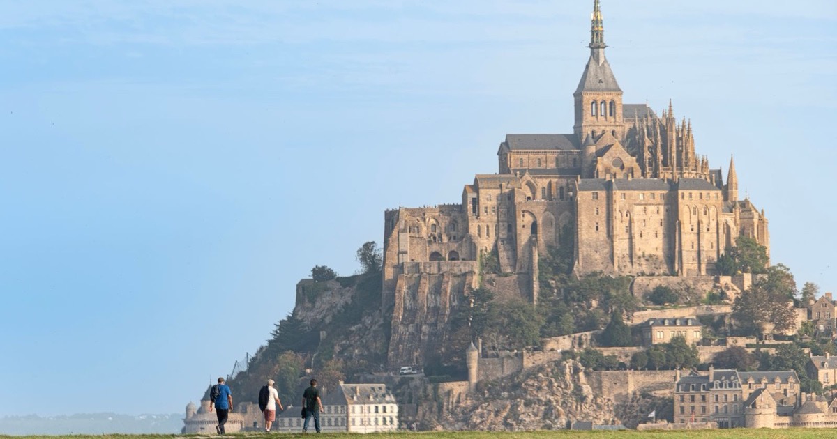

For travelers who crave a blend of history, dramatic coastline, and rugged scenery, the Mont Saint Michel hiking trails deliver an experience that few destinations…
For travelers who crave a blend of history, dramatic coastline, and rugged scenery, the Mont Saint Michel hiking trails deliver an experience that few destinations can match. Stretching from the iconic tidal island down into the rolling dunes of Normandy, these routes invite you to walk where medieval pilgrims once trod while catching glimpses of the Atlantic’s ever‑changing moods. Whether you are mapping out a day‑long trek or a series of short walks, the area’s network of signposted paths makes it easy to tailor your adventure. Bring a reliable pair of boots, a weather‑ready jacket, and a sense of curiosity, and you’ll discover why these trails rank among the most rewarding in western Europe.
What makes the hiking paths around Mont Saint Michel unique for travelers?
The geography of the Mont Saint Michel region creates a rare combination of tidal flats, cliff‑top panoramas, and sheltered woodlands. As the tide rolls in, the surrounding bay transforms into a vast, reflective basin that can be crossed on foot at low water, offering a surreal sense of walking on the sea itself. At high tide, the same area becomes a dramatic shoreline, framing the abbey against a backdrop of rolling waves.
Beyond the natural drama, the routes are steeped in cultural layers. The Chemins du Mont‑Saint‑Michel network links nine historic entry points, forming a pilgrimage trail that has guided travelers for nearly a millennium. Along the way, stone markers and ancient chapels punctuate the journey, turning a simple hike into a living museum of medieval devotion and Norman heritage.
Practical considerations also set these trails apart. The regional tourism office provides up‑to‑date trail maps for Mont Saint Michel, and most paths are maintained to a standard that accommodates both seasoned trekkers and family‑friendly hikes. Signage is clear, and many routes intersect with designated parking areas, making spontaneous detours easy to manage.
Which trails offer the best coastal views near Mont Saint Michel?
The Mont Saint Michel coastal trail stretches along the bay’s edge, delivering uninterrupted vistas of the Atlantic and the island’s silhouette. Starting at the village of Beauvoir, the route follows the historic causeway, climbing gentle rises that overlook the tidal flats. On clear days, the view extends to the distant cliffs of the Côte d’Argent, providing a perfect backdrop for photography spots Mont Saint Michel.
For those seeking a longer seaside experience, the Baie du Mont Saint Michel loop combines cliff‑top paths with beach walks. This circuit incorporates sections of the best hikes Mont Saint Michel, weaving through sand dunes that shift with each tide. The loop is popular among hikers who appreciate varied terrain and the chance to observe local wildlife, such as migratory birds that use the bay as a stopover.
| Trail | Length (km) | Difficulty | Highlights |
|---|---|---|---|
| Coastal Trail (Beauvoir to the Abbey) | 5.2 | Easy | Panoramic sea views, tidal causeway |
| Baie Loop | 12.4 | Moderate | Dunes, birdwatching, sunset over the water |
| Cliffside Path (Le Mont‑Saint‑Michel to Genêts) | 8.0 | Moderate | Rugged cliffs, historic lighthouse |
| Salt Marsh Walk | 3.6 | Easy | Low‑tide beach, marine flora |
Weather Mont Saint Michel hiking can shift quickly, so packing waterproof layers and checking tide tables before setting out is advisable. The coastal routes are generally well‑drained, but sections near the marshes may become muddy after rain, so sturdy hiking boots are recommended.
Where can I find hidden forest loops on Mont Saint Michel’s hiking routes?
The Mont Saint Michel forest loop lies inland, away from the bustling shoreline, and offers a quieter alternative for those who prefer shaded trails. Beginning at the parking area near the village of Saint‑Marc, the loop winds through a mixed‑wood forest of oak, beech, and pine. The path is marked as Mont Saint Michel forest loop on most trail maps, and it intersects with several secret paths that lead to small clearings and historic waystations.
One of the lesser‑known routes, often referred to as a Mont Saint Michel secret path, branches off the main loop near the old stone bridge. This trail follows a historic pilgrim track that once connected the abbey to inland monasteries. Along the way, you’ll encounter remnants of medieval stone walls and occasional chapels, adding a sense of discovery to the hike.
Families appreciate the gentle gradients and the abundance of natural learning opportunities along these forested walks. The area is home to a variety of fauna, including deer and a range of songbirds, making it an ideal setting for nature‑focused outings. For photographers, early morning light filtering through the canopy creates striking contrasts, perfect for capturing the serenity of Normandy hiking.
How difficult are the most challenging hikes at Mont Saint Michel?
The rugged coastline that frames the iconic abbey offers routes that test stamina and sure‑footedness. The Roche Bleue Ridge Trail climbs steep limestone cliffs for roughly 12 km, with an elevation gain of 620 m. Expect exposed sections where wind can be strong, and a few scramble‑type passages that require careful footing. The trail is best tackled in the early morning to avoid the heat that can build up on the sun‑baked rocks.
Another demanding option is the Grand Forest Loop, a 15‑km circuit weaving through dense oak and beech stands. Though the ascent is gentler than the ridge, the loop incorporates several undulating ridgelines, totaling about 540 m of cumulative climb. Muddy undergrowth can appear after rain, so waterproof boots are essential. This hike rewards perseverance with panoramic views of the bay that are invisible from the more frequented paths.
| Trail | Length (km) | Elevation Gain (m) | Difficulty Rating |
|---|---|---|---|
| Roche Bleue Ridge Trail | 12 | 620 | Hard |
| Grand Forest Loop | 15 | 540 | Hard |
| Coastal Sand Dune Walk | 8 | 120 | Moderate |
| Pilgrimage Heritage Path | 6 | 80 | Easy |
When is the ideal season to hike the trails around Mont Saint Michel in 2026?
The region’s maritime climate creates distinct windows for optimal trekking conditions. Late spring, from mid‑April to early June, brings mild temperatures and blooming wildflowers that line many forest routes. Summer months, especially July and August, offer longer daylight hours but can produce strong sea breezes that make exposed coastal sections feel cooler.
Autumn, spanning September through early November, provides a comfortable mix of warm days and crisp evenings, while the foliage turns amber, adding visual interest to the forest loops. Winter hikes are possible, yet shorter daylight and occasional tidal surges require careful planning.
- Mid‑April to early June – gentle weather, low visitor density.
- Late June to early July – extended daylight, occasional gusts.
- July to August – warm days, sea breezes moderate heat on cliffs.
- September to early November – stable temperatures, colorful foliage.
- Early December – cooler but still walkable, fewer crowds.
What safety tips should hikers follow on Mont Saint Michel’s tidal paths?
The bay’s tides are famously swift; water can rise several meters within an hour, turning a dry sandbank into an impassable inlet. Before setting out, consult the official tide tables for the day and set an alarm to alert you when the water approaches the marked safety line. Mobile apps that track real‑time water levels are also reliable tools.
Always wear sturdy, ankle‑supporting footwear. The mix of loose sand, wet mud, and occasional shell fragments can cause slips, especially on the narrow coastal trail that skirts the lagoon. Carry a compact rain jacket, as weather can shift rapidly, and keep a lightweight waterproof backpack to protect maps or a printed guide.
Travel with a companion when possible, and let someone outside the area know your intended route and expected return time. If you find yourself caught by an incoming tide, move quickly toward higher ground, following the clearly painted “high‑ground” arrows that line the main paths. In the unlikely event of injury, the nearest medical post is located in the village of Pontorson, reachable by a short shuttle service that runs during peak visiting seasons.
Which trails are suitable for families and beginners at Mont Saint Michel?
The Sentier des Bouchots offers a gentle, well‑marked route that circles the low‑lying marshes surrounding the island. The path is mostly flat, with short wooden boardwalk sections that keep feet dry during high tide. Signage is clear, and the distance from the parking area to the first viewpoint is under two kilometres, making it an ideal choice for children aged six and up. Along the way, families can pause at interpretive panels that explain the tidal dynamics of the bay, turning a simple walk into an informal lesson.
Another beginner‑friendly option is the Grand Coquillage Loop, a 3.5‑kilometre circuit that starts at the Abbey’s lower courtyard and follows the coastal edge before looping back through a pine‑lined promenade. The trail’s gentle gradients and frequent rest spots—some equipped with benches and drinking fountains—allow a leisurely pace. Dogs on leashes are permitted on most of the loop, provided they are kept under control during the busier summer months.
For groups with very young children or limited stamina, the Pointe du Roc spur provides a short, 800‑metre out‑and‑back walk that leads to a rocky overlook with panoramic views of the surrounding sandbanks. The route is paved and includes a few low steps, but the ascent is modest. Parents can use the nearby information kiosk to check tide times before setting out, ensuring a safe return before the water rises.
How can I access trail maps and navigation tools for Mont Saint Michel hikes?
Official trail maps are distributed by the Office de Tourisme du Mont-Saint-Michel and can be collected free of charge at the visitor centre located near the Abbey entrance. These paper maps display the entire Chemins du Mont‑Saint‑Michel network, including colour‑coded difficulty levels and points of interest such as historic chapels, birdwatching towers, and picnic areas.
Digital navigation is equally straightforward. The French national mapping agency, IGN Geoportail, provides an interactive web map that overlays the footpaths with topographic detail. By enabling the “GPX export” function, hikers can download routes directly to a handheld GPS device or a smartphone app. For those who prefer a one‑tap solution, the AllTrails and Komoot apps both host user‑generated reviews, elevation profiles, and offline map options for the Mont Saint Michel area.
- Visit the official Mont‑Saint‑Michel tourism website for downloadable PDF maps and tide tables.
- Use the IGN Geoportail portal to obtain high‑resolution topographic layers and export GPX files.
- Download the AllTrails app, search “Mont Saint Michel,” and save the desired trail for offline use.
- Install Komoot, create a custom route using the “Plan” feature, and sync it to a compatible GPS watch.
- Pick up a printed map at the Abbey’s information desk; maps are updated annually.
- Scan QR codes posted at major trailheads; each code links to a mobile‑friendly map with real‑time weather alerts.
- Consult the local tourist office for a free “Family Trail Pack” that includes child‑friendly route suggestions and safety tips.
What wildlife and flora might I encounter on Mont Saint Michel’s walking routes?
The intertidal zones around the bay host a variety of marine mammals, most notably grey seals that haul out on sandbanks during low tide. Early morning walks often reveal groups of seals basking on the mudflats, while birdwatchers can spot flocks of brent geese and waders such as curlews and oystercatchers feeding along the shoreline. During migration periods, the area becomes a waypoint for raptors, including short‑eared owls that glide low over the water.
Terrestrial habitats are equally diverse. The dunes are dominated by hardy grasses like sea oat and marram, which stabilize the shifting sands. In spring, patches of sea lavender and yellow horned poppy add colour to the landscape, while the higher, slightly less saline meadows support heather, gorse, and occasional wild orchids. Hikers who venture into the pine‑covered coastal forest may encounter deer and foxes, especially at dawn or dusk.
Botanical interest extends to the salt‑marsh flora that thrives in the brackish pools near the tidal channels. Species such as glasswort, sea purslane, and samphire are adapted to the fluctuating salinity and provide food for invertebrates, which in turn attract shorebirds. Keeping an eye on the ground cover can reveal small insects like sand wasps and beetles, offering a glimpse into the intricate food web that sustains the region’s wildlife.
How do the historic pilgrimage routes integrate with modern hiking trails at Mont Saint Michel?
The medieval pilgrimage network, known as the Chemins du Mont‑Saint‑Michel, has been woven into today’s signposted footpaths. Along the coastal ridge, stone markers indicate the centuries‑old waypoints that once guided barefoot pilgrims, while contemporary trailheads provide parking and information panels. Hikers can follow the same limestone steps that monks once trod, but benefit from maintained surfaces, clear wayfinding, and occasional interpretive displays that explain the spiritual significance of each segment.
Because the routes converge at the abbey, most modern loops incorporate a segment of the historic path before branching toward the surrounding dunes or forest circuits. This overlap lets walkers experience the solemn atmosphere of the pilgrimage while enjoying the flexibility of today’s trail options, such as shorter circular routes or longer multi‑day treks that link nearby coastal villages.
Where are the best spots for photography along Mont Saint Michel’s hiking paths?
One of the most striking vistas opens from the “Pointe du Phare” viewpoint, where the tide sweeps the sand flats and the abbey rises against the sky. Early morning light casts soft shadows on the granite cliffs, highlighting the layered geology. A short detour to the “Roche aux Oiseaux” promontory offers a natural frame of the island with seabirds in flight, ideal for wildlife‑focused shots.
Further inland, the forest trail that loops through the “Bois de la Chaume” provides a contrast of green canopy and the distant silhouette of the Mont. Late‑afternoon sun filters through the trees, creating dappled patterns that work well for atmospheric landscape images. For night photography, the illuminated abbey reflected in the tidal pool at high tide creates a dramatic mirror effect.
Frequently Asked Questions
Are the Mont Saint Michel hiking trails open year‑round?
Yes, the majority of the marked trails remain accessible throughout the year, though some coastal sections may be temporarily closed during extreme weather or exceptionally high tides. Seasonal maintenance is performed in the spring, ensuring that signage and footbridges are safe for walkers. Checking the local tourism office website before departure provides the latest updates.
Do I need a permit to hike the coastal paths around Mont Saint Michel?
No special permit is required for day‑time hiking on the public footpaths. However, certain protected areas, such as the bird sanctuary near the “Roche aux Oiseaux,” may restrict access during nesting periods. In those cases, signage will indicate any limitations, and visitors are asked to respect the temporary closures.
How long does it take to complete the most popular loop trail?
The classic 10‑kilometre loop that circles the bay and returns to the abbey typically takes between three and four hours at a moderate pace. This estimate includes short stops for viewpoints and a brief rest at the tidal information board. Hikers who prefer a leisurely pace or wish to explore side paths should allow an extra hour.
Can I combine a visit to the abbey with a hike on the surrounding trails?
Absolutely. The abbey’s visitor centre opens early, allowing a quick interior tour before heading out onto the trails. Many hikers start their walk from the abbey’s western gate, following the pilgrim route that leads directly onto the coastal loop. This arrangement lets you experience both cultural heritage and natural scenery in a single day.
What public transportation options are available to reach the trailheads?
Regular regional buses connect the town of Pontorson with the Mont Saint Michel parking area, where most trailheads begin. During the summer season, a shuttle service runs from the train station in Avranches to the “Pointe du Phare” trailhead. Train connections from major cities such as Rennes and Paris terminate at Pontorson, making the hike reachable without a car.
Is there a guided hiking tour for the secret paths of Mont Saint Michel?
Several local outfitters offer guided walks that explore lesser‑known routes, including the “Sentier des Anciens” that weaves through hidden valleys and old stone walls. These tours typically last two to three hours and provide historical anecdotes, tide‑timing advice, and safety tips. Reservations are recommended during peak tourist months.
What is the difficulty level of the tidal crossing trail?
The tidal crossing, which links the mainland to the island at low tide, is classified as moderate due to uneven sand, occasional shallow water, and the need to monitor tide tables closely. Hikers should be comfortable with basic navigation and possess appropriate footwear. The crossing can be completed in 30‑45 minutes when conditions are favorable.
Are dogs allowed on the Mont Saint Michel hiking routes?
Dogs are permitted on most of the public footpaths, provided they are kept on a leash no longer than two metres. Certain wildlife protection zones, especially near the bird sanctuary, prohibit dogs to avoid disturbance. Always check local signage before entering restricted sections.
Where can I find restrooms and water sources along the trails?
Restroom facilities are available at the main parking lot, the abbey visitor centre, and at the “Pointe du Phare” information kiosk. Portable water fountains are installed near the trailheads and at the midway rest point on the coastal loop. Carrying a small reusable bottle is advisable, as some sections have limited refill options.
How can I stay updated on trail closures due to weather?
The regional park authority posts real‑time alerts on its official website and on a dedicated mobile app that sends push notifications for closures or hazard warnings. Local tourist offices also display notices on bulletin boards near the main entrances. Subscribing to the park’s newsletter ensures you receive the latest information before you set out.
Plan your hike with the tide schedule in mind, pack sturdy shoes, and allow extra time for unexpected detours; the blend of history and natural beauty along Mont Saint Michel’s paths rewards a thoughtful, well‑prepared approach.
Reviewed by our editor for Europe
Marco BianchiEurope Editor
Europe travel writer focused on city culture, museums and historic routes across the continent.
More articles by Marco Bianchi →